
GPS (Global Positioning System)
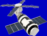 The GPS, or Global Positioning System, is the high-tech application of one of the most fundamental principles of geometry. Surveyors routinely use geometry and triangulation to map and lay out areas of land. Until recently they used high quality optical telescopes called 'theodolites' and mechanical measuring devices to carry out the surveying process. But as technology has changed, so has the surveyor's craft. The laser, digital electronics, space travel, and several other technological advances have all combined to make surveying and triangulation far more precise and accurate than they used to be, and allow measurements to be routinely obtained from distances that traditional surveyors could only dream about. GPS, the Global Positioning System, has come about as a natural development of the advances in surveying technology. It consists of a series of 24 satellites in orbit 11,000 miles (17,600 kilometers) above Earth.
Each satellite orbits Earth once every 12 hours, and each carries a highly accurate clock with the ability to measure time to 3 billionths of a second. All 24 of the satellite clocks are synchronized with each other and each one broadcasts its own time signature. The GPS receiver is programmed to read the time signature of four satellite signals, and to measure the difference in time between receipt of the four signals. Since the signals all travel at exactly the same speed, and all of the satellites are different distances away from any particular point on the planet, each signal takes a measurably different amount of time to reach a particular receiver. This time difference is used by the receiver to calculate the distance to each of the 4 satellite sources and thus triangulate the exact location of the receiver on the planet's surface. To complete the system, 5 ground stations located throughout the world monitor and maintain the proper functioning of the satellites.
The GPS can fix one's location anywhere on the planet to within a few inches. This allows very precise navigation and control of the movement of people and things on the planet's surface. Unfortunately, this sort of accuracy could be useful to an enemy. The U.S. government intentionally scrambles the signal slightly to reduce the available accuracy, just enough to avoid untoward use of the positioning system while maintaining an acceptable degree of accuracy for the system to be generally useful. The GPS is already being used to produce the most accurate maps ever, for surveying and documentation, for prospecting, for on-the-fly navigation systems, and in agriculture to help regulate the application and use of fertilizers. Other uses for this ingenious system are being developed every day.
About the Author
Richard M J Renneboog, MS
 Richard M. J. Renneboog is an independent private technical consultant and writer in both chemical and computer applications. Endeavors have included preparation of scripts for instructional and promotional video, corporate website design, curriculum development for training in advanced composites technology, and development.