
Finding Ice In The Rocks--Evidence Of Earth's Ice Ages
 In the late 1700s, geologists began trying to determine how huge boulders of granite weighing several tons could have moved as much as 80 km (50 miles) from their origins in the Swiss Alps. Some thought they must have been transported by the Great Flood. Geologists who examined the alpine valleys downslope from glaciers noted that the hard bedrock was rounded and polished except for parallel gouges called 'striations' that pointed downhill. The rocks in the valley walls above the glacier, where ice had not reached, were rough and uneven. Others examined thick mounds of unsorted sediments ranging in size from fine powder to large boulders. Though the mounds were found far from any glaciers, they resembled piles of sediment along the margins of existing glaciers.
Early in the 19th century, Louis Agassiz examined the landforms and sediments surrounding existing glaciers. He studied the packed ice of glaciers and explained how the ice could accumulate over years, then begin to move slowly over the land. When he had compiled enough evidence, he asked prominent European geologists to accompany him on a field trip to the Jura Mountains to examine the landforms and sediments both near and far from existing glaciers. He was able to establish that glaciers had at one time moved over large parts of the northern continents. The slow moving ice would advance much like a bulldozer over the land, pushing rocks as well as small pebbles ahead of it, plucking up huge boulders, scratching the solid bedrock below with the rocks it carried. Mounds of 'lateral moraine' would spill along the sides much like gravel mounds along the edges of a road grader's blade, and a 'terminal moraine' would be left in a heap where the glacier's progress ended.
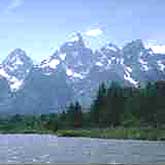
Glaciers have shaped much of the land, forming spectacular mountain scenery and gently rolling lowlands. A mountain valley cut by a glacier tends to have a broad, flat valley floor rather than the steeper V-shape of a river valley. Glacial outflow streams carrying smaller debris eroded their own smaller valleys, then deposited distinctive sediments. Moving glaciers ground downward unevenly, often leaving hanging valleys in cliff faces where waterfalls now plunge. The Great Lakes of North America were excavated by glaciers. The elevation drop at Niagara Falls between Lake Erie and Lake Ontario is a spectacular example of the uneven basal erosion by glaciers. And glaciers have given us glacial geologists an interesting vocabulary to describe the many erosional forces and features of glaciers: eskers, drumlins, moraine, till, outflow streams, meltwater, ablation, kettle lakes, fjords, ar'tes, and more.
About the Author
Claire-Jean Korzenewski, BS
 Claire-Jean Korzenewski has a B.S. in geology and experience in petroleum exploration. She is an educator with public school teaching experience in junior high and high school sciences. Claire-Jean is now a freelance writer who makes communications more effective - to inform, to educate, and to enhance profits for businesses and individuals.