

Laser Guide Stars
 Did you ever wonder why we have to have the Hubble Space Telescope so high up in the Earth's orbit? Why not just make a bigger and better telescope on the surface?
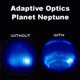
The reason is that our atmosphere disturbs the heavens' image. Even on a clear night, there are countless movements of hot and cold air that cause, among other things, light diffraction and small particle scattering. All of these effects distort the image seen through a telescope. These disturbances can even be seen with the naked eye: they are the reason stars appear to twinkle in the night sky. That's why we have space telescopes, to avoid the atmospheric distortions. But imagine if we could somehow predict or measure these distortions in real time and correct for them.
That is exactly what laser guide stars and adaptive optics are all about. Originally developed in the US during the cold war for the Star Wars anti-missile project, this technology was declassified several years ago and is now being used to 'clean-up' Earth-based telescope images. Astronomers shine a really bright laser beam up into the night sky, close to the heavenly object (planet, star, galaxy, nebula, etc.) they want to observe. Then they image (record in real time with a camera) this laser beam, which appears in the sky as a bright, artificial laser-produced star. The image analysis tells them exactly how the laser beam has been distorted while passing through this particular part of the atmosphere. This then allows them to literally adapt / deform their telescope's mirrors with small actuators in such a way as to undo the atmospheric distortions. Sometimes dented and crinkly mirrors are just what you need to get a clear image.